All

At Flycom Technologies, we strive for continuous improvement, which means optimising existing processes and learning new methodologies, in addition to new sensors and platforms for capturing spatial data and new software for processing it. We also offer new knowledge and experience to our customers through an expanding list of products.
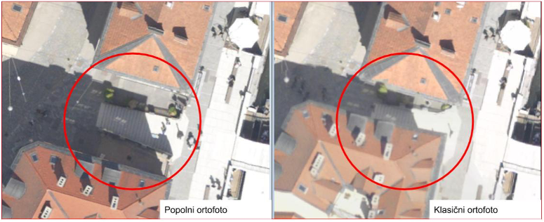
In the last year, we have added a complete orthophoto to our digital photogrammetry products. (slovenian: popolni ortofoto).
As with conventional orthophotos, these are aerial photographs converted into an orthogonal projection, taking into account the relief data and the absolute orientation of the photographs. The effects of camera optics, camera tilt and the influence of terrain undulations are removed – the product is a geometrically correct representation of the surface in the chosen projection plane with a uniform scale over the entire area.
Although classical orthophoto is a very useful product in general, because it provides direct visual information about the area depicted and is a useful basis as a basic and accurate map, it has certain limitations in urban areas. In conventional orthophotos, objects such as buildings and bridges are not taken into account in the DMR (digital elevation model), which is used as a projection surface for orthorectification of the images. Since aerial images are captured using the principle of central projection, they show distortion in the position of the depicted content. Distortion is caused by the elevation of the relief and also on objects that are above the relief (e.g. buildings and trees). These are shifted radially outwards from the centre of the image due to central projection. The higher the object and the further it is from the centre of the image, the greater the radial displacement. The roofs of the buildings are therefore offset on the orthophoto, which can be seen in the form of sloping buildings. Similarly, bridges may appear deformed because they are not on the surface of the relief
With a full orthophoto, we try to overcome the shortcomings of the classic orthophoto listed above. Since the transformation from central to orthogonal projection in a conventional orthophoto is only performed on the basis of the DMR, only points on the surface that coincide with the DMR are correctly mapped. This problem is solved by producing a complete orthophoto, where the orthorectification includes not only the DMR but also the built objects. Their heights are obtained from photogrammetric point clouds. Orthorectification maps the tops of buildings and bridges to geometrically correct positions.
This website uses cookies to enhance your experience. Some are essential for site functionality, while others help us analyze and improve your usage experience. Please review your options and make your choice.
If you are under 16 years old, please ensure that you have received consent from your parent or guardian for any non-essential cookies.
Your privacy is important to us. You can adjust your cookie settings at any time. For more information about how we use data, please read our privacy policy. You may change your preferences at any time by clicking on the settings button below.
Note that if you choose to disable some types of cookies, it may impact your experience of the site and the services we are able to offer.
Some required resources have been blocked, which can affect third-party services and may cause the site to not function properly.
This website uses cookies to enhance your browsing experience and ensure the site functions properly. By continuing to use this site, you acknowledge and accept our use of cookies.